In a Report of the New Jersey Geological survey I stumbled upon this tidbit. It is amazing where you will find tiny tidbits that can help your story.
1852.—Winter of 1851-2, cold; mean temperatures of the months, 3° to 8° below the average; East river crossed on the ice January 30th, and for three days following; Susquehanna at Havre de Grace frozen over for seven weeks; cold and snows as far south as New Orleans and Jacksonville, Fla.
Showing posts with label Places. Show all posts
Showing posts with label Places. Show all posts
Thursday, September 21, 2017
Monday, July 31, 2017
Big Bonanza
The Big Bonanza was the events surrounding the Silver Mines in Nevada in the 19th Century. Dan deQuille, History of the Big Bonanza wrote the book in 1876 giving an account of the lives and people of Nevada.
Below I'm sharing the foreward written by Mark Twain, it is quite an endorsement.
One easily gets a surface-knowledge of any remote country, through the writings of travellers. The inner life of such a country is not very often presented to the reader. The outside of a strange house is interesting, but the people, the life, and the furniture inside, are far more so.
Nevada is peculiarly a surface-known country, for no one has written of that land who had lived long there and made himself competent to furnish an inside view to the public. I think the present volume supplies this defect in an eminently satisfactory way. The writer of it has spent sixteen years in the heart of the silver-mining region, as one of the editors of the principal daily newspaper of Nevada; he is thoroughly acquainted with his subject, and wields a practised pen. He is a gentleman of character and reliability. Certain of us who have known him personally during half a generation are well able to testify in this regard.
MARK TWAIN.
Hartford, May, 1876.
Tuesday, July 18, 2017
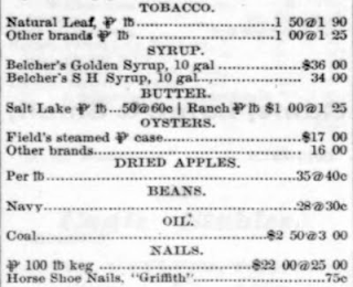
1867 Costs in Montana
The information below comes from "The Montana Post" (Virginia City, Montana Territory Jan. 5, 1867 newspaper. What I found is a market report of the costs of various products. They state theprices in gold or large lots from first hands, unless otherwise stated, and that in filling orders, higher rates have to be paid. I've enlarged the column and it is in several parts.


Tuesday, July 11, 2017
Elephant Rusks in Vermont
Below is an article from Country Gentleman ©1865 Vol.26
The Tusk of an Elephant found in Brattleboro'
The tusk of a fossile elephant was found in a muck bed about five feet below the surface, on the farm of D. S. Pratt, in this town, on Saturday, Sept. 2, by a workman who was digging muck. The tusk is 44 inches in length, and 18 inches in circumference at the largest end, and 11 inches at the smallest. It is in a fair state of preservation, although some parts of it crumbled after being exposed to the air. The workman on discovering it took a piece to Mr. Pratt, remarking as he handed it to him. that he had found a curious piece of wood. Mr. Pratt on looking at it discovered its true nature. This tusk belonged to a species of elephant long since extinct, supposed to be the Elephas Primogenius (or mamir»th) Bhimeitback, that inhabited the northern parts of North America, having wandered across the Siberian plains to the Arctic Ocean and Behring Straits and beyond to this country south to about the parallel of 40°. Their bones show them to have been about twice the weight and one-third taller than our modern species.
The remains, (tusks, teeth, and several bones.) of one of these elephants were found at the summit of the Green Mountains, at Mount Holly, in 1848, by workmen engaged in building the railroad from Bellows Falls to Rutland. These remains were found in a muck-bed, 11 feet below the surface and at an elevation of 1415 feet above tide water. Most of the bones found, including a molar tooth, were taken by the workmen and others and carried out of the State. The most perfect tusk was secured by Prof. Zadock Thompson and is lodged in the State Cabinet at Montpelier. This tusk was 80 inches long and four inches in diameter. The molar tooth, now in possession of Prof. Agassiz, weighs 8 pounds and presents a grinding surface of 8 inches long and 4 broad. A plaster cast of it is on exhibition with the tusk at our State Cabinet.
Thursday, June 29, 2017
Lipman's Great German Bitters
We've all read and heard about the tonics and various cure all medicines sold years ago. Below is the logo of Lippman's Great German Bitters, the second image is the list of what it cures or strengthens in the individual taking the medication or in this instance the bitters. These images come from the Charleston daily newspaper.


Here is a link to a label a little older than the above ad that was produced in Savannah, Ga in 1874
There were a few bottle images that came up on an image search.


Here is a link to a label a little older than the above ad that was produced in Savannah, Ga in 1874
There were a few bottle images that came up on an image search.
Tuesday, June 27, 2017
1871 Cruises to Florida
Charleston S.C. was a busy port and in 1871 there were many ships headed to Florida from Charleston. Below is an ad from The Charleston Daily News July 17, 1871. What I find interesting from this ad is it lists when you depart and when you would return give us a great example of the time involved in steam travel on the lower east coast.


Wednesday, June 7, 2017
Four dead in Five Seconds
We've all heard about the Gun Fight at the OK corral which happened on Oct. 26, 1881 in Tombstone Arizona. But I stumbled upon this gunfight and thought I'd share a little about it.
In El Paso, Texas on April 14, 1881 the famous "Four Dead in Five Seconds" gun fight occurred. This is one of those cases where the town hired a gun fighter to be the Marshal. You can read more about this gun fight on Wikipedia.
There's a short video of a reenactment of this incident on You Tube.
There was a blurb written in the Old West Gunfights webpage.
Monday, May 8, 2017
The Statue of Liberty
The corner stone for the statue of liberty was laid July 5, 1884 on Bedloe's Island a military post. I believe most of us know that the statue was a gift from Franc, but were you aware that it was often referred to as Barholdi's statue? The statue was built in France then dismantled and shipped to New York. After several months, nearly a year and a half of reconstruction and touch ups the statue was dedicated on Oct. 28, 1886.
From "A Standard History of Freemasonry" ©1899 we have this account of that day:
We are assembled here to-day in the face of you all to erect a statue representing liberty enlightening the world, a work of art grand in its conception and birth. As Auguste Bartholdi sailed into the bay of New York, a few years ago. the sight of the great city before him was grand, but grander the thought which found lodgment in his mind, of placing at this entrance to the continent, something that would welcome to these shores all who love and seek liberty, and the thought at this time crude though grand, gave birth to this statue; grand in its figure—colossal in size; grand in its practical use—lighting the storm-tossed mari
ner to a safe harbor, and grand in its very name and the significance thereof—"Liberty Enlightening the World:" "liberty" of thought, of conscience, of action, that true liberty that is not license, but which finds its highest development in obedience to constituted authorities and law; "enlightening"— how necessary enlightenment to true liberty and the highest appreciation thereof; "world"—yes, to the whole world does our continent open its arms and bid it welcome to the blessings of liberty.
From the "History of the city of New York" ©1896 we also have this excerpt:
This statue, at present adorning the entrance to the inner harbor of New York, is much larger than was the Colossus of Rhodes ; the figure is one hundred and sixty-two feet in height, and from the top of the pedestal the head-dress reaches an elevation of three hundred and twentysix feet. The pedestal is a rectangular shaft placed in the parade of the star-shaped granite fortification known as Fort Wood. The weight of the entire structure is forty-eight thousand tons. The work of constructing the pedestal was done under the supervision of Gen. C. P. Stone, engineer-in-chief. The tiara upon the head, and the torch carried aloft as a beacon in the right hand, are illuminated by electricity.
Because it admirably embodies the spirit of the statue, we append the sonnet written by Emma Lazarus.
THE NEW COLOSSUS.
Not like the brazen giant of Greek tame,
With conquering limbs astride from land to land,
Here at our sea-washed sunset gates shall stand
A mighty woman with a torch, whose Hame
Is the imprisoned lightning, and her name
Mother of Exiles. Front her beacon hand
Glows world-wide welcome ; her mild eyes command
The air-bridged harbor that twin-cities frame.
" Keep, ancient lands, your storied pomp !" cries she
With silent lips. " Give me your tired, your poor,
Your huddled masses, yearning to breathe free;
The wretched refuse of your teeming shore, —
Send these, the homeless, tempest-tost, tome.
1 lift my lamp beside the golden door! "
Thursday, April 6, 2017
California Gold Rush
The term California Gold Rush entered into our history reports in the late 1800's as best as I can tell. I was going to take the time and outline key events of the Gold Rush but came across a web page that has already done for us. The search for Gold helped in the expansion of California and in points west. It dated from 1848-1859.
California Gold Rush Timeline
And don't ignore sites written with children in mind. Sometimes it helps to simplify points by reading over such websites. Kidport Reference Library They also have a lot of links to other sites.
And if your looking for a story and how the California Gold Rush affected some of the towns, Munsey Magazine, Vol 10 has an article Mr. Justice Field located in Google books.
Friday, March 31, 2017
The Martha's Vineyard Campgrounds
Last week Paul and I celebrated 43 years of marriage.
I mention that to give the reason for my choice of locations for today's blog post. There is a book in Google books, A History of the Wesleyan Grove, Martha's Vineyard, camp meeting: ©1858' that will give you a great overview of what we now refer to as the "Campgrounds." The gingerbread houses bring tourist from all over. As a kid I used to sell bunches of flowers to the "old" (I may be that age now) ladies in the campgrounds. I also attended the Methodist church in the campground, and our high school class graduation ceremony was held there. I have many other memories associated with the campgrounds but that's not why you come to read my blog.
The first camp meeting was held in 1835 and the book linked above only covers to the year 1858. People came with their tents and camped on the grounds. The preacher's tent was elevated and in front of the group. There were only 9 tents that formed the first circle. However makeshift tents were made from sails and awnings. A well was dug for pure water. The land is right off the Oak Bluffs harbor. A quote from those first meetings was "Surely the Lord is in this place." God moved and continued to move for many years and decades. So much so, that tents were replaced with wooden camp houses. The grand illumination, which we grew up knowing as Illumination night, was filled with lighting paper lanterns and hanging them from houses and lines strung for the occasion. It's still owned by the same camp meeting association of 1835 and in August, they still host the Grand Illumination Night.
Here's a picture I took on my last visit to the Vineyard showing one of the gingerbread houses.

Saturday, March 18, 2017
50 Largest Cities 1880, 1850
Below is a graph of the largest cities in America from census reports. 1880 is in the left hand column and 1850 is the right. Charleston, SC is highlighted showing it's decline from 1850 to 1880.
 If you'd like to view the original source here is a link

Friday, March 17, 2017
Pilot Mountain
There are many grand places to see in America. One of these wonders is Pilot Mountain in North Carolina. In a book called "Mountain Scenery" ©1859 we find the general description of Pilot Mountain and location. I love the second to last paragraph in this excerpt because of the language used by the writer.
The Pilot Mountain is situated in the eastern end of Surry, near the line of that county and Stokes. It rises, an isolated pile, in the midst of a plain. No other mountain, or even considerable hills, being within many miles of it. It would seem as if the mountains, having concentrated all their strength, make in it a last desperate effort and die away. There is a hotel kept at the foot of the mountain, where many travellers resort in the hot season.
"The ascent of the mountain to the spring, an agreeable spot of refreshment, more than half way to the top, is so gradual that the visitor may proceed on horseback. From this spot the acclivity becomes steeper, until you reach the pinnacle, which presents an elevation of some two hundred feet The only pass to the summit is on the north side, narrow, steep, and laborious of ascent; yet it is considered by no means a difficult achievement. And the visitor is rewarded for his toil by an'enchanting prospect of the surrounding country and mountain scenery in the distance. The dense and widestretching forest appears dotted with farms and hamlets. The Blue Ridge reposes in a long line of mountain heights on the northwest. Eastward, in Stokes County, the Saura Town Mountains rise to the view,—some of whose summits exceed the Pilot in height.^ And the Yadkin River, flowing down from the hills of Wilkes, and washing the western base of the mountain, 'rolls its silvery flood,' in a mazy line of light, through the wilderness. The Pilot Mountain is nearly or quite three thousand feet above the level of the sea. Its position and form, not height, make it an object of interest.
"At a point on the road, between the Little. Yadkin and Mount Airy, the traveller may obtain the most singular, and, perhaps, the finest view of the Pilot. One end of the mountain is there presented to the beholder in its most perfect pyramidal form. Its vast sides are seen sweeping up from the surrounding forest, gradually approaching and becoming steeper, until they terminate at the perpendicular and altar-like mass of rock which forms the summit. It here gives an idea of some gigantic work of art, so regular, and so surprisingly similar are the curves of its outlines, and so exactly over the centre, does the towering pinnacle appear to be placed.
"It satisfies the eye, and fills the soul with a calm and solemn delight to gaze upon the Pilot. Whether touched by the fleecy clouds of morning, or piercing the glittering skies of noon, or reposing in the mellow tints of evening; whether bathed in the pale light of the moon, or enveloped in the surges of the tempest, with the lightning flashing around its brow, it stands ever, ever the same; its foundations in the depths of the earth, and its summit rising in solitary grandeur to the heavens, just as it rose, under its Maker's hand, on the morning of creation, and just as it shall stand when the last generation shall gaze upon it for the last time."
The Pilot Mountain is reached from Greensborough, or High Point, to Salem, by Clemmens & Co.'s line of stages; from thence by hired conveyance. Salem is a very pretty and quiet town, and will well repay a visit. The cemetery is a favorite walk, and will, probably, compare with anything of the kind in the South. A gentleman, who had travelled over much of Europe, once said that Salem reminded him more of a German village than any place he had seen in this country. There is a Female Institute of much celebrity and age in the place. The town was originally settled by the Moravians, and still bears many marks of their taste and public spirit.
Thursday, February 9, 2017
Niagara Falls Suspension Bridge
The bridge was built for the railroad and commerce between Canada and the U.S. A temporary bridge went up in 1848 then the completed bridge in 1855. However it wasn't limited to trains, a toll was established for horse & carriage and carriage passengers. In 1860 daily trains crossed the bridge. It was closed in 1897 and dismantled. An interesting tidbit was that the cables were found to not have deteriorate of the course of 50 years of use.
Houghtaling's Handbook of Useful Information ©1884 has this to say:
Railway Suspension Bridge, Niagara Falls.
Engineer. John A. Roebling. Height of towers on American side, 88 feet. Height of towers on Canada side, 78 feet. Length of bridge, 800 feet. Width of bridge, 24 feet. Height Lbove the river, 250 feet. Number of cables, 4. Diameter of cables, 10 inches, containing about 4,000 miles of wire. Ultimate capacity of the 4 cables, 12,400 tons. Total weight of bridge, 800 tons. Distance between railway track and carriage road below, 28 feet. Cost of construction, 500.000 dollars. Bridge first opened for railway traffic, March 8, 1855. Estimated depth of water in the channel beneath the bridge, 250 feet. Velocity of current,30 miles per hour. Velocity of Whirlpool Rapids,27 miles per hour Quantity of water passing through the gorge per minute, 1,500,000,000 cubic feet.
In Burke's descriptive guide for Niagara ©1850 we find even more tidbits about the bridge and it's original construction.
THE SUSPENSION BRIDGE?
This truly fairy-like work was commenced in February, 1849, under the suprintendence of Charles Ellet, Jr., Esq., of Philadelphia, an Engineer of good previous reputation, and who, in this work, added much to his fame.
The bridge was contracted to be built for the " Niagara Falls Suspension Bridge Company," on the Canada side, and " The Niagara Falls International Bridge Company," on the American side conjointly ; a bill for the purpose being passed by the Legislature of each country.
The manner in which the first line of connection was formed, was at once simple, yet ingenious. A kite was procured, to the tail of which was a string, and by flying this on the one side, and letting it out until it was over the other side, the gorge was spanned by the string, by which a cord was drawn Awful catastrophe.
across, and by means of this cord, a rope of sufficient strength to draw a cable, which latter, being well secured on both sides, was the means of transit for the first wire-cable of 36 strands, No. 10 wire, which was 1160 feet in length. Towers had now been erected on each bank, 800 feet apart, by which this wire-cable was secured, and on the 13th of March, just one month from the commencement, Mr. Ellet crossed in an iron basket, suspended from the cable. This conveyance was used constantly by the workmen in constructing the bridge. And even many persons paid for the novelty of a trip across in this frail track.
A foot-bridge, three feet in width, was soon constructed, and over this a great number of persons passed, each paying 25 cents to the contractor. A similar foot-bridge was now formed parallel to this, and the basket-cable in the middle.
A terrific scene occurred just about this time. Whilst the workmen were busy at the second footbridge, which was constructed about 250 feet from the American side, and about 150 from the British, a tornado from the s. w., struck it, turning it quite over. Six men were at work upon the flooring of the bridge at this awful moment, two of whom in a most unaccountable manner made their way to the shore upon fragments of boards. The unfinished structure was torn and wafted backwards and forwards like the broken web of a spider, and four helpless human beings, 200 feet from the shore, supported by two strands of No. 10 wire, were in constant expectation of a headlong fall and plunge into the rapids below ! Oh, who can fathom those men's thoughts just then ? But the tiny thread which held them to existence, proved strong enough to outlast the gale. On the first cessation of the tornado's force, a brave fellow-workman manned the iron basket, and with a ladder proceeded amid the pelting of the furious rain to save the sufferers. He reached the wreck ; he placed his ladder in communication with it, and the basket thus affording a means by which all were brought back safe to terra-firma, uninjured in person, but well nigh scared to death.
On the 26th of July following, Mr. Ellet drove a span of horses and a heavy carriage over and back, accompanied by his lady.
A disagreement, which had for some time existed between the directors and Mr. Ellet, now came to an open rupture, and the work was discontinued for some time.
The bridge, which we see, is not the structure Height of the Bridge.
originally intended. This being merely preparatory to the great structure, which was to have been suspended from stone towers, 70 feet high, and which would have been 10 feet higher than the present bridge, and wholly independent of it
The present bridge was at first economically formed of very slight materials, it not being expected to last longer than, until the great bridge was constructed, about a year and a half. It has, however, been strengthened materially, and is now capable of sustaining 250 tons, and is in use as a thoroughfare, unshaken by the greatest pressure.
The floor of the bridge is 230 feet above the river, and the depth of the river immediately under the bridge is 250 feet
Monday, January 30, 2017
Mason Dixon Line
We've all heard and possibly have used this phrase when referring to the North and South of the United States. However, we've come a long way from what or rather how this phrase came into use. It's from an old surveyors map, one produced by Charles Mason and Jeremiah Dixon from 1763-1767. Below you can see a short explanation of it from the 1884 copy of Houghtaling's Handbook of Useful Information, also I have a link to The History of Mason & Dixon's Line ©1855 for even more information.
Mason and Dixon's Line.
A name given to the southern boundary line of the Free State of Pennsylvania which formerly separated it from the Slave States of Maryland and Virginia, It was run—with the exception of about twenty-two miles—by Charles Mason and Jei emiah Dixon, two English mathematicians and surveyors, between Nov. 15, 1763, and Dec. 26, 1767. During the excited debase in Congress, in 1820, on the question of excluding slavery from Missouri, the eccentric John Randolph of Roanoke made great use of this phrase, which was caught up and re-echoed by every newspaper in the land, and thus gained a celebrity which it still retains.
Thursday, January 26, 2017
Fictitious Names of Cities
Continuing with the them of fictitious names of places in the 19th century, today's tidbit comes from Houghtalings Handbook of Useful Information ©1884.
BLUFF CITY.—A descriptive name popularly given to the city of Hannibal, Missouri.
CITY OF BROTHERLY LOVE.—Philadelphia is sometimes so called, this being the literal signification of the name.
CITY OF CHURCHES.—A name popularly given to the city of Brooklyn, N.Y., from the unusually large number of churches which it contains.
CITY OF ELMS.—A familiar denomination of New Haven,
Conn., many of the streets of which are thickly shaded with lofty elms.
CITY OF MAGNIFICENT DISTANCES.—A popular deidgnation given to the city of Washington, the capital of the United States, which is faid out on a very large scale, being intended to cover a space four miles and a half long, and two miles and a half broad, or eleven square miles. The entire site is traversed by two sets of streets from 70 to 100 feet wide, at right angles to one another, the whole again intersected obliquely by fifteen avenues from 130 to 160 feet wide.
CITY OF NOTIONS.—In the United States, a popular name for the city of Boston, Mass., the metropolis of Yankeedom.
CITY OF ROCKS.—A descriptive name popularly given, in the United States, to the city of Nashville, Tenn.
CITY OF SPINDLES.—A name popularly given to the city of Lowell, Mass., the largest cotton-manufacturing town in the United States.
CITY OF THE STRAITS.—A name popularly given to Detroit, which is situated on the west bank of the river or strait connecting Lake St. Clair with Lake Erie. Detroit is a French word, meaning " strait."
CRESCENT CITY.—A popular name for the city of New Orleans, the older portion of which is built around the convex side of a bend of the Mississippi River.
EMPIRE CITY.—The city of New York, the chief city of the western world, and the metropolis of the Empire State.
FALL CITY.—Louisville, Ky.;—popularly so called from the falls which, at this place, impede the navigation of the Oldo River.
FLOUR CITY.—A popular designation, in the United States, for the city of Rochester, NY a place remarkable for its extensive manufactories of flour.
FLOWER CITY.—Springfield, Illinois, the capital of the State, which is distinguished for the beauty of its surroundings.
FOREST CITY.—1. Cleveland, Ohio;—so called from the many ornamental trees with which the streets are bordered. 2. A name given to Portland, Maine, a city distinguished for its many elms and other beautiful shade-trees.
GARDEN CITY.—A popular name for Chicago, a city which is remarkable for the number and beauty of its private gardens.
GARDEN OF THE WEST.—A name usually given to Kansas, but sometimes applied to Illinois and others of the Western States, which are all noted for their productiveness.
GATE CITY.—Keokuk, Iowa;—popularly so called. It is situated at the foot of the lower rapids of the Mississippi.
GOTHAM.—A popular name for the city of New York.
HUB OF THE UNI VERSE.—A burlesque and popular designation of Boston, Mass., orignating with the American humorist, O. W. Holmes.
IRON CITY—A name popularly given in the United States, to Pittsburg, Pa., a city distinguished for its numerous and immense iron manufactures.
MONUMENTAL CITY.—The city of Baltimore; — so called from the monuments which it contains.
MOUND CITY.—A name popularly given to St. Louis, on account of the numerous artificial mounds that occupied the site on which the city is built.
PURITAN CITY.—A name sometimes given to the city of Boston, Mass., in allusion to the character of its founders and early inhabitants.
QUAKER CITY.—A popular name of Philadelphia, which was planned and settled by William Penn.
QUEEN CITY.—A popular name of Cincinnati;—so called when it was the undisputed commercial metropolis of the West.
QUEEN CITY OF THE LAKES.—A name sometimes given to the city of Buffalo, N. V., from its position and importance.
RAILROAD CITY,—Indianapolis, the capital of the State of Indiana, is sometimes called: by this name, as being the terminus of various railroads.
SMOKY CITY.—A name sometimes given to Pittsburg, an important manufacturing city of Pennsylvania.
Wednesday, January 25, 2017
Fictitious Names of States
Today's tidbit again comes from the 1884 edition of Houghtaling's Handbook, available at Google books. I thought this list would be helpful when writing dialogue for some of our characters. Someone who has grown up in an area might use some of these terms rather than use the actual name of a state. Enjoy!
BADGER STATE.—A name popularly given to the State of Wisconsin.
BAY STATE.—A popular name of Massachusetts, which, previous to the adoption of the Federal Constitution, was called the Colony of Massachusetts Bay,
BAYOU STATE.—Aname sometimes given to the State of Mississippi, which abounds in bayous, or creeks.
BEAR STATE.—A name by which the State of Arkansas is sometimes designated, on account of the number of Bears that formerly infested Its forests.
CREOLE STATE.—A name sometimes given to the State of Louisiana, in which the decendants of die original French and Spanish settlers constitute a large proportion of the population.
DIAMOND STATE.—A name oometlmes given to the State of Delaware, from its small size and great worth, or supposed Importance.
EMPIRE STATE.—A popular name of the State of New York the most populous and the wealthiest State in the Union.
EXCELSIOR STATE.—The State of New York, sometimes so called from the motto "Excelsior" upon Its coat of arms.
FREESTONE STATE.—The State of Connecticut;—sometimes so called from the quarries of freestone which it contains.
GRANITE STATE.—A popular name for the State of New Hampshire, the mountanlous portions of which are largely composed of granite.
GREEN-MOUNTAIN STATE.—A popular name for the State of Vermont, the Green Mountains being the principal mountain range in the State.
HAWKEYE STATE.—The State of Iowa;—said to be so named after an Indian chief, who was once a terror toVoyageurs to its borders.
HOOSIER STATE.—The State of Indiana, the inhabitants of which are often called Hoosiers. This word is a corruption of Husher, formerly a common term for a bully, throughout the West.
KEYSTONE STATE.—The State of Pennsylvania ;—so called from its having been the central State of the Union at the time of the formation of the Constitution. If the names of the thirteen original States are arranged in the form of an arch, Pennsylvania will occupy the place of the keystone.
LAKE STATE—A name popularly given to the State of Michigan, which borders upon the four lakes, Superior, Michigan, Huron, and Erie.
LONE-STAR STATE.—The State of Texas;—so called from the device on its coat of arms.
LUMBER STATE.—A popular designation for the State of Maine, the inhibltants of which are largely engaged in the business of cutting and rafting lumber, or of converting it into boards, shingles, scantlings, and the like.
MOTHER OF PRESIDENTS.—A name frequently given. in the United States to the State of Virginia, which has furnished six presidents to the Union.
MOTHER OF STATES.—A name sometimes given to Virginia, the first-settled of the thirteen States which united in the declaration of independence.
NUTMEG STATE.—A popular name, in America, for the State of Connecticut, the inhabitants of which have such a reputation for shrewdness, that they have been jocosely accused of palming off wooden nutmegs on unsuspecting purchasers, instead of the genuine article.
OLD COLONY.—A name popularly given to that portion of Massachusetts included within the original limits of the Plymouth colony, which was formed at an earlier date than the colony of Massachusetts Bay.
OLD DOMINION.—A popular name for the State of Virginia.
OLD NORTH STATE.—A popular designation of the State of North Carolina.
PALMETTO STATE.—The State of South Carolina;—so called from the arms of the State, which contain a palmetto.
PENINSULAR STATE.—The State of Florida;—so called from its shape.
PDXE-TREE STATE.—A popular name of the State of Maine, the central and nothern portions of which are covered with extensive pine forests
PRAIRIE STATE.—A liame given to Illinois in allusion to the wide-spread and beautiful prairies, which foron a striking feature of the scenery of the State.
TURPENTINE STATE.—A popular name for the State of North Carolina, which produces and exports Immense quantities of turpentine.
New Yorke & The Brooklyn Bridge
There are events and items in life that you take for granted. One of those items for me was made clear from the movie Kate & Leopold when referencing the building of the Brooklyn Bridge. With that in mind today's excerpt comes from Houghtaling's Handbook ©1884.
First talked of by Colonel Julius W. Adams about 1855. Act of incorporatlonpassed April, 1866. Survey begun by John A. Roebling, 1869. Construction begun January 2,1870. First rope thrown across the river August 14, 1876. Master Mechanic Farrington crossed in a boatswain's chair August 25, 1876. Depth of the New York foundation below high water mark, 78 feet 6 inches. Depth of the Brooklyn foundation below high water mark, 45 feet. The New York tower contains 46,945 cubic yards of masonry; the Brooklyn tower, 88,214. Weight of the Brooklyn tower, about 98,079 tons. Weight of the New York tower, about a third more. Size of the towers at high water line, 140x59 feet; at roof course, 186x58 feet. Height of the towers above high water mark, 278 feet 6 inches. Height of roadway in the clear in the middle of the East River, 185 feet. Grade of the roadway, 8 feet 8 Inches to 100 feet. Width of the promenade in the centre of bridge, 16 feet 7 inches. Width for railway on one side of the promenade, 12 feet 10 inches. Width of carriage way, on the other side of the promenade, 18 feet 9 inches. Width of bridge 85 feet. Length of main span, 1,595 feet 6 inches. Length of each land span, 930 feet. Length of the Brooklyn approach, 971 feet. Length of the New York approach, 1,560 feet. Length of each of the four great cables, 8,578 feet 6 inches; diameter, 15% inches: number of steel galvanized wires in each cable, 5,484; weight of each cable, about 800 tons. Ulti.nate strength of each cable, 15,000 tons. Weight of steel in the suspended superstructure, 10,000 tons. Total cost, 15,000,000 dollars. Opened for traffic in 1888.
First talked of by Colonel Julius W. Adams about 1855. Act of incorporatlonpassed April, 1866. Survey begun by John A. Roebling, 1869. Construction begun January 2,1870. First rope thrown across the river August 14, 1876. Master Mechanic Farrington crossed in a boatswain's chair August 25, 1876. Depth of the New York foundation below high water mark, 78 feet 6 inches. Depth of the Brooklyn foundation below high water mark, 45 feet. The New York tower contains 46,945 cubic yards of masonry; the Brooklyn tower, 88,214. Weight of the Brooklyn tower, about 98,079 tons. Weight of the New York tower, about a third more. Size of the towers at high water line, 140x59 feet; at roof course, 186x58 feet. Height of the towers above high water mark, 278 feet 6 inches. Height of roadway in the clear in the middle of the East River, 185 feet. Grade of the roadway, 8 feet 8 Inches to 100 feet. Width of the promenade in the centre of bridge, 16 feet 7 inches. Width for railway on one side of the promenade, 12 feet 10 inches. Width of carriage way, on the other side of the promenade, 18 feet 9 inches. Width of bridge 85 feet. Length of main span, 1,595 feet 6 inches. Length of each land span, 930 feet. Length of the Brooklyn approach, 971 feet. Length of the New York approach, 1,560 feet. Length of each of the four great cables, 8,578 feet 6 inches; diameter, 15% inches: number of steel galvanized wires in each cable, 5,484; weight of each cable, about 800 tons. Ulti.nate strength of each cable, 15,000 tons. Weight of steel in the suspended superstructure, 10,000 tons. Total cost, 15,000,000 dollars. Opened for traffic in 1888.
Thursday, January 12, 2017
The Bronx Zoo
On Nov. 8, 1899 the Bronx Zoo opened as the New York Zoological Park. In 1899 there were 261 acres. New York purchased the property for a mere thousand dollars from Fordham University with the condition that the area be used for parks and no further building (for private homes, businesses, etc) of the area.
Google Books has a copy of the second addition of the Popular official guide to the New York Zoological Park ©1900 the following year of the Parks opening. Below is the preface. Here is a link to the entire guide book.
PREFACE.
The opening of the Zoological Park marks another great step toward the education of the people of the City of New York. It will bring the beauties and wonders of living Nature within reach of hundreds and thousands who are unable to travel. Like its predecessors in this field of popular education, the Park is maintained by the City, while its collections of animals and all of its present buildings are due to the generosity of citizens of New York. "We look to the continued and increasing support of all classes of people for whose education and amusement the Park is designed, rather than for the exclusive interests of science.
Although the Park is only one-third of the way toward completion, the Zoological Society believes that visitors will welcome a popular and reliable guide to what has already been accomplished. One year ago we began active work, and after two years of planning and organization ceased to speak publicly of our plans for the future. This handbook describes and pictures only what has actually been accomplished up to the day of going to press.
We bespeak for the Director and his colleagues on the Zoological Park staff, as well as for the Architects, indulgence for such shortcomings as are inseparable from such a difficult undertaking as this, during its first year. As rapidly as possible the incomplete parts of the Park will be taken in hand and brought to a finish. It has been no trifling matter to provide plans and surveys, building materials and workmen for our twenty-two installations, proceeding simultaneously with the construction by the City of miles of walks, roads, sewers and water-lines ; to finish-Bonds and entrances, trim the forests, establish a nursery, grade and plant miles of walk - borders, and build retaining walls ; to select a staff of assistants, collect animals, write labels, disburse $170,000 in small sums, without loss or dispute, and finally, during the last few weeks to improve Lake Agassiz sufficiently to make it a full and wholesome body of water.
That all the above has actually been accomplished in one year's time, without costly mistakes, or losses on account of changes in plans, and with no friction whatever, is certainly a cause for congratulation. We have enjoyed the constant and capable co-operation of the Park Department for the Borough of the Bronx and its engineers, as well as the generous support of the Mayor and other City authorities.
Executive Committee
Of The Zoological Society
The Bronx 1874
The Bronx is as familiar to us today as New York City. However, it wasn't until 1874 that the Bronx was annexed into it's own county. Below you'll find a brief history of the Bronx and the last paragraph points out the dates significant to the 19th century. The excerpt comes from Historical guide to the city of New York ©1909 pg.179
HISTORICAL SKETCH OF THE BRONX.
The Borough of the Bronx derives its name from the first white settler, Jonas Bronck, who settled near theBronx Kills in 1639 and called his home Emmaus. An adjacent river became known as Bronck's (shortened later to Bronx) River and in recent times the same name was applied to the whole borough. Many Indians of the Moh1can nation, Suwanoy tribe and Weckquaeskeeks local tribe, branches of the Algonquin race, made this borough their home, dwelling on the shores of the Hudson, the Sound and the Bronx River. They left various Indian names behind them, such as Acquehaunck, Mannepies, Quinnahoung Kekeshick, Laap-hawach-king, Mosholu. Many of the old titledeeds date back to early purchases from Indian sachems.
The earliest Dutch settlement was probably in 1654 at Westchester. The English soon followed, some of the first titles being granted by Governor Nicolls.
Many Revolutionary scenes were enacted in this borough and a full quota of its citizens went forth to serve and die in defence of their rights. The dreaded Neutral Ground extended from the Harlem to the northern limits of the present borough. Pelham saw the " Battle of Pelham Neck," while Westchester may well boast of its Battle of Westchester Creek (see Section V). Other sections could tell of individual engagements with the King's forces.
The early and middle parts of the Nineteenth Century brought great changes. Extensive farm lands were made to bring forth the fruits of the earth; then came the successful business men, who located here their country , estates and elegant mansions, many examples of which are yet to be found, in spite of the advance of the city.
The year 1874 brought annexation to the city of New York of 13,000 acres of the western part of the Bronx,followed in 1895 by the remaining 20,000 acres. And now these 33,000 acres of hill and plain are fast merging 1nto that wonderful city that is proud to style itself " America's Metropolis."
Tuesday, December 20, 2016
Warm Springs Toll Bridge North Carolina 1879
Below you'll find the actual writing of the portion of the act of the North Carolina General Assembly allowing the Warm Springs Toll Bridge Company to charge for tolls across the bridge. As an author I'm always looking for the actual costs of items or services during the time period I'm writing.
Sec. 5. That the company shall be entitled to receive Rates of ton. the following toll, to-wit: Six-horse wagons seventy-five cents, four-horse wagons fifty cents, three-horse wagons forty cents, two horse wagons twenty-five cents, one horse wagon fifteen cents, man and horse ten cents, loose horses and mules five cents each, cattle, sheep and hogs two and one-half cents each, pleasure carriages four horse one dollar, two horse fifty cents, horse and buggy twenty-five cents.
Ratified the 5th day of March, A. D. 1879.
Subscribe to:
Posts (Atom)